1912: Muriwai Mystery
January 13, 2025
By AHNZ
Muriwai Beach, West Auckland, has a very long history. Even 100 years ago historians and naturalists were able to excavate even older remains from the rubbish piles they had left behind. For example, the unusual discovery of the Muriwai beach boomerang in 1925 stands out. Ref. 1925: Maori Boomerang Discovered, AHNZ
Various groups inhabited the area long before the founding of Auckland as the capital of the Crown Colony of New Zealand. Hayward and Diamond (1978) name 10 time periods starting from the legendary times of the Fairy Folk (Turehu or Patupaiarehe,) and chief Maruiwi whose name sounds a lot like the place. Various groups arrived and occupied the place over hundreds of years of conflict and settlement leaving behind old forts, terraces, storage pits, rock carvings, and even mummified remains.
“It was probably attractive because of its sheltered cultivation sites in the valley, its large swamp and bush resources, and its proximity to the toheroa beds of Muriwai beach and fishing spots to the south.” wrote Hayward and Diamond. I would also suppose that the Muriwai gannet colony would of great use before the Muriwai Lodge (cafe/restaurant) came along in 1922.
Also back then, in from 5 March, 1921, motorcar races were attracted to the beach but for the natural beach roadway rather than the food. There was also forestry along this coast and once an amazing beach trainline. Ref. Encyclopedia of New Zealand
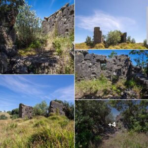
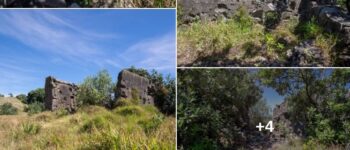
However, the mysterious concrete/stone/brick/wooden ruins in these images (left) from Derelict New Zealand don’t seem to date from any of those times. Evidence points to it being a WW2 era military observation post despite its unconventional structure.
Despite being up and down this beach many times I have never visited it myself. When Derelict New Zealand asked me what I could find out I wrote to the West Auckland Historical Society as well as Muriwai Gold Links. Correspondence…
AHNZ: Gidday there, I’m on a history quest to discover what this old concrete building is. Goes back to the 1940s at least as aerial images show. As it’s in your neighbourhood at Muriwai I hope you might point me in the right direction to finding out more. Much thanks, Rick
Reply: Hi Rick. On one of our old course sketches it is marked as Old Fisherman’s hut. Will dig further for you. Cheers. Kind Regards. Andrew Jackson. General Manager
Nothing more from Mr Jackson as yet but I’m grateful to know what the golf club think. I put that to the Historical Society and it was suggested there was once a fishing hut too but that it had been demolished by the club.
West Auckland Historical Society (WAHS) have a secondary source they didn’t name, a longtime resident. His father (primary source) said the structure was a WW2 military observation post from around 1942. It was prompted by Whenuapai Airbase becoming a major concern during the Pacific War. However, from the many remains I’ve visited at Bomber Point it’s very clear that the Muriwai Mystery Ruins bare no resemblance to those. It’s much more primitive.
Joan Green, WAHS; Email 1: “On behalf of West Auckland Historical Society, thank you for your enquiry about the old concrete building remains at Muriwai Beach. One of the few longtime residents still living at the beach remembers being told by his father that they are remains of a World War 2 military observation post. War was declared in September 1939 but later, (1942 – 1945) when the local Whenuapai Airbase became a main centre for New Zealand’s military operations, special attention was given to increasing protection of the surrounding areas from possible Japanese attack or invasion. So, such an installation is more than likely, especially as it is located in an ideal position but there doesn’t appear to be any proof anywhere. There is a lot of information available online now, on various websites official and otherwise, about New Zealand’s military history, including that of the U.S. forces stationed in the country at that time. It is recorded that a unit of U.S.Marines had a camp at Muriwai Beach and some information about that is in a local book “Doing it Themselves” The Story of Kumeu, Huapai and Taupaki by Deborah Dunsford, published in 2002, and probably available through your local library system. My elderly contact is furthering his enquiries so we may gain a bit more information which I will pass on, in the meantime I hope you find this useful and wish you good luck with your research.” – Joan, WAHS committee/researcher
“Still people suggesting bunker, gun emplacement. It doesn’t resemble any of the other bunkers I’ve seen around the country. And they all have a flat concrete roof. This one has a different design…” – Derelict NZ, Facebook (2025)
“During World War II, the New Zealand Government feared that the Japanese army could invade Auckland along the west coast, landing at Muriwai. During this period, a United States Marine Corps camp was established at Muriwai, in part due to these fears.” – Doing It Themselves: the Story of Kumeu, Huapai and Taupaki, Deborah Dunsford (2002,) Wiki
Joan Green, WAHS; Email 2: “Hi Rick, Bit more info. has come to light: another contact, who worked at the Golf Club for yonks, remembers there were two buildings in the area. One was a weekend fishing bach, located between the Nos 6 & 7 greens which were then in a very different area to the current layout being much closer to the beach. This building was later considered a safety hazard and demolished by the club years ago — so quite likely the fisherman’s hut on their map, ( date?). My original contact also confirms the second building and its disappearance — both sites had been regular play areas for the local kids hence the safety concerns with the more flimsy bach, plus it got in the way of the mowers and players! Good luck with the dig. Joan”
The original earlier cable had a fault, and was redone. My whanau has resided in Muriwai since 1922, the building was always thought to be associated to this original cable” – Mary Dormer, Facebook (2025)
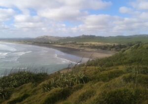
Others have suggested the remains may relate to the Trans-Tasman communications cable. In 1912 Auckland had a direct hardline to Sydney in 1912 via Muriwai Beach. Ref. NZ Herald (1912)
And, also from Muriwai another line was installed to connect to the Wellington-to-Sydney cable in 1932. Ref. Auckland Star
It may be that the ruins once belonged to a contractor or private group associated with that old infrastructure. Not a winch though as the Auckland Star reported the use of horses to pull the cable inland from the ship. However, perhaps the 1912 generation were smarter and did have a winch?
It’s pretty clear from Derelict NZ’s photos that local stone has been cemented together to build the thing, along with some bricks. The timber plank formwork has left an impression on the cement. It sure doesn’t look military. If some bored marines were given a project to keep them occupied this is not what they would come up with, even on their own time. The better place for an observation post would be on the cliffs (image, left.)
So, I’m going with the 1912 cable theory: “Bondi to Muriwai laying the Pacific telegraph cable. Work commenced in Bondi on 16 November 1912, the Silvertown was to lay the cable at sea at the rate of about 180 miles a day, doing eight or nine knots. The cable finally reached Muriwai on the 7th of December, a little longer than the predicted 6 days and was ready for telegraphs to be sent on the 30th December 1912.” Ref. Auckland Libraries Research, Facebook (2018)
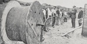
These contractors (left) would have required a base HQ to lay the telegraph cable. Where better than near to their starting place at the beach? Also, the cable would be ready to use for communications as soon as it came on shore. Until the permanent connection to a New Zealand Post Office could be made (at Riverhead initially, by the looks of it) that would be at the beach too.
To know for sure we’d have to dig a bit deeper into this history. It may turn out that it was a military observation post after all, or part of some other forgotten project like fishing for toheroa or racing cars. However, the leading answer in my opinion is that this structure was part of our early communications history. It may even have served as a 2-room telegram office and, temporarily, the control room for Auckland to talk to the rest of the world.
Hopefully we’ll learn more about this unconventional building and the attempted answer from this post will lead to better ones.
—
Image ref. Ruins montage, Derelict NZ, Facebook (2025)
Image ref. View looking north over Muriwai beach. AHNZ Archives (2017)
Ref. Prehistoric Archaeological Sites of the Waitakere Ranges and West Auckland, New Zealand, Hayward and Diamond (1978)
Ref. “The landing-place selected on the west coast for the Sydney cable is Rangira Beach, just north of Oaia Island, and opposite Muriwai Creek. The distance from this spot to the new Auckland Post-office is approximately twenty-two miles. For the first two miles from the beach the connecting cable can be laid in the Muriwai Creek, then ten miles trenching over easy undulating country, the subsoil of which is clay, with no hard ground or rocks, to Harking’s Point, from where the cable can be safely laid down the Waitemata Harbour,” – Appendix to the Journals of the House of Representatives (1912,) Papers Past
Update from Golf Links: “Sorry, I have no further info on this building. The structures to the right are a test site for outdoor building surfaces.” – email to AHNZ (15/1/2025)
Update from Joan at WAHS provides key evidence from Alice Maud Rea’s book…
——– Forwarded Message ——–
| Subject: | Re: Muriwai mystery |
|---|---|
| Date: | Fri, 17 Jan 2025 18:45:15 +1300 |
| From: | Joan Green |
| To: | Rick Giles <anarchist_history@anarkiwi.co.nz> |
3 thoughts on "1912: Muriwai Mystery"
Leave a Reply
 Like Comment Share



Hi Rick,
I stumbled on all of this while researching for a book I am compiling on Muriwai Beach. I was asked about the building recently and despite walking past it for over 60 years I have never made an enquiry. I few days ago I walked past it and intend to go back to have a close look. I wondered if US soldiers had a few pop shots at it. I have found two 1942 US cartridges in the area. From the 1920s there was a very small toheroa inspectors cottage at the access by the rocks, as a longshot I wonder if the stone building was for that purpose and predated the wooden cottage/shed.
It may have had something to do with the car racing.
Well I’m glad you don’t think the toheroa and car racing ideas are too fringe. Hope you learn more and I’m backing the cable idea.
I did get a partial message this week from Derelict New Zealand saying “N41/950635” is the “full file” but I don’t know what to do with that.
West Auckland Historical Society This is what one of our researchers Joan Green has found: Perhaps the following will help solve the mystery, being a reference from the book “They Came for Kauri but ……” written by Mrs Alice M. Rea in 1963. Page 62 Para 1 reads: “The overseas telephone cable between Australia and New Zealand comes ashore 1 1/2 miles north of Muriwai. There have been three cable – laying operations. The remains of the first anchorage hut may still be seen on the golf links. The anchorage point for the last two cable – laying operations was the present hut just above the creek”. The golf links referred to are the Muriwai Golf Club, plans for which started in 1955 with the course to be laid out immediately behind the sandhills. Over the following twenty years constant erosion of the foreshore became a major problem for the club and necessitated the construction of new greens further back. This remained an ongoing issue for many more years, consequently, the complete, current course is much further inland than the original. The first anchorage hut remains were situated between the original Nos. 6 & 7 greens, now vanished from sight under the sand but I understand are marked on a map in the clubhouse. Too difficult & costly to remove, the structure was regarded as just another hazard for the golfers and mowers to contend with ! The book was produced by the Early Settlers’ Association of Waimauku as part of the Centenary Celebrations in 1963. Mrs Rea lived at Muriwai Beach and travelled extensively gathering information from many residents also, the manuscript was thoroughly checked by senior members of the committee. Resource Books of Waimauku published a Second Edition in 2013 for the 150th Anniversary, copies of which are still available for purchase. – FB 2025