1916: St George’s Bay
April 17, 2025
By AHNZ
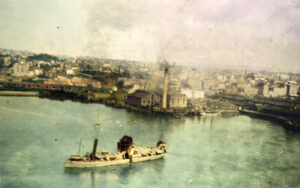 An early aerial shot of Auckland Central from 1916, taken from a New Zealand Flying School aircraft. The harbor dredge is in the foreground of what was St George’s Bay. It has been reclaimed from the sea but was named after George Cooper, Hobson’s taxman.
Behind we can see Albert Park (walled off?) and the domain. The building with the big stack is the new electric power station on King’s Wharf.
I guess future sites of KFC and McDonalds on Quay Street is just off the bow of the dredge. Beach Road isn’t the beach road anymore!
The flying school was right next door and this picture captures the dredge in the act of helping Aucklanders transform their city. A disappearing bay being disappeared.
—
Image ref. Ronald Burns Bannerman personal album collection, Air Force Museum of New Zealand. Timespanner. AHNZ enhanced and coloured (2025)
Ref. Auckland’s new electrical power house, which will soon be ready to supply the city’s customers with light and power, Auckland Libraries
Ref. Street map of the city and suburbs of Auckland compiled from the latest information (1917,) Auckland Libraries Heritage Collections Map 3115


