1953: Auckland Domain Reservoir
February 24, 2022
By AHNZ

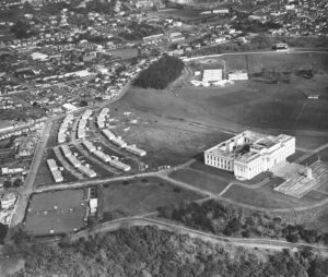
Old photos of Auckland War Museum show a slope running off to the south. It was around here, where US Forces camped during the American Invasion (1942.) The high point is on the crater rim of an old volcano and the playing fields are inside that crater formed 100,000 years ago.
The second photo (right) shows that those old military huts have been re-located to behind the museum where they were used as temporary housing during a housing crisis. These days the same problem is solved, and created, by Central Government taxing us or printing money to put people into hotels. “In total, the Government paid motels and hostels $365 million in the past year to accommodate those in need.” ref. Exclusive: Record $365 million spent on emergency housing, 1News (Feb 2022)
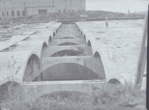
I think of this area as ‘out the back’ of the Museum although more recently I’ve noticed it being used as a main entrance. Where is that slope? The area is flat and grassy. The answer is in this photo (left.)
Here we see the museum ‘out the back’/south side before the dome was constructed. In 1953 an 18 million litre water reservoir was constructed.
 I would like to see inside that today! Maybe, since we have no air force these days, one day we will. It would make a devastating target on the moral and water supply of our city. Perhaps even symbolic of where US Forces protecting New Zealand once camped, providing we still remember back that far. Heads up.
—
Image ref. Showing the final stages of construction of the reservoir in the Auckland Domain, with the Museum in the background, Auckland Libraries Heritage Collections
Image ref. Titoki Street Transit Camp, 1946, Auckland Libraries Heritage Collections
 Like Comment Share


