1853: Oamaru Ferry Theory
December 28, 2021
By AHNZ
 Oamaru had been a wasteland until Hugh Robison and his brother built and lived in a muster’s raupo/flax/sod hut in 1853. Here they created a sheep station called the Oamaru Run. The North Otago settlement became a thriving town thanks to its port that served pastoralists and the great Otago Gold Rush.
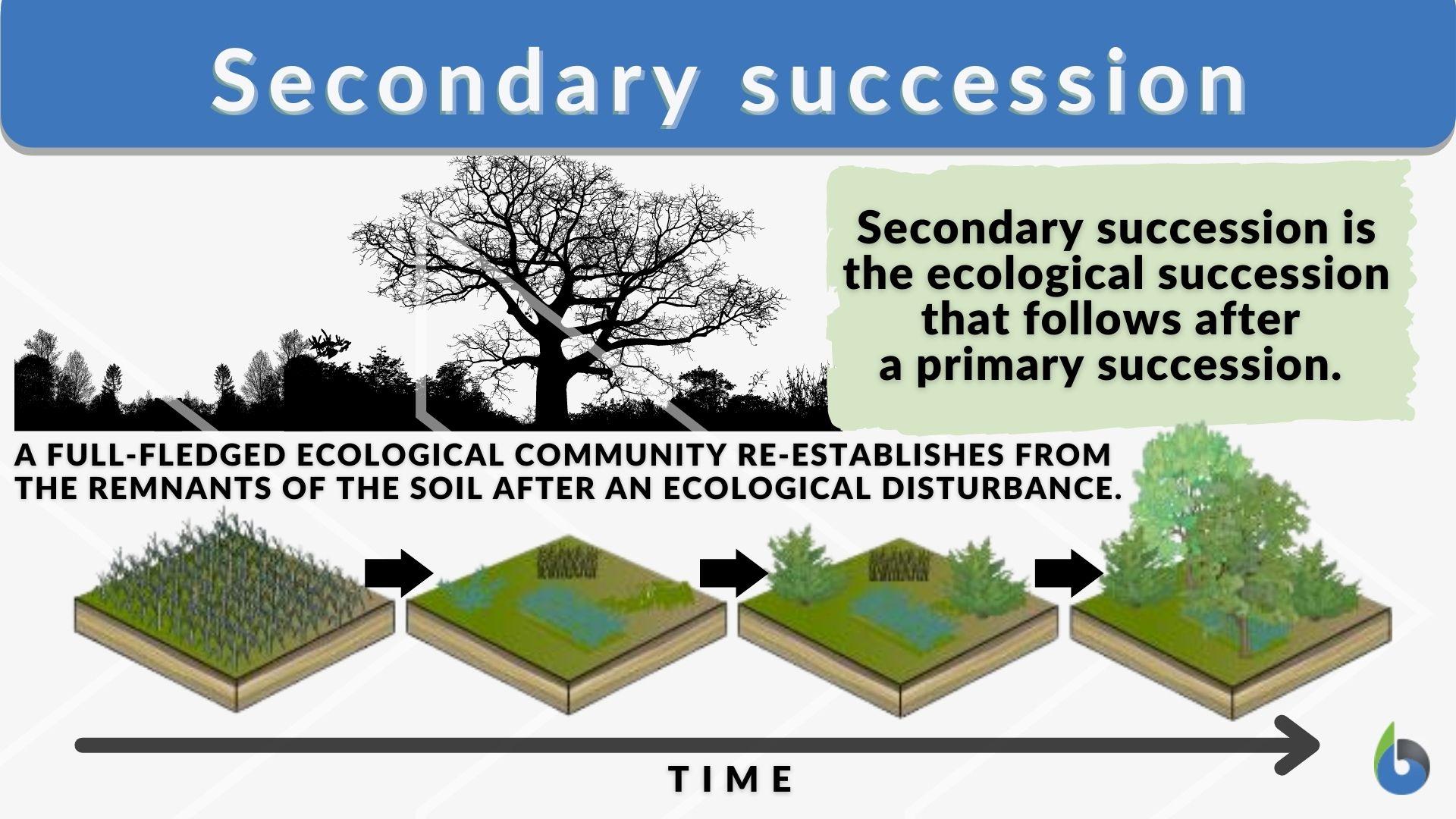
By the mid-1880s vast areas of the Otago Run was full of thistles, similar perhaps to the situation that would fill the Matata block with ragwort and contribute to the Exploding Pants problem. It was a case of what we called in high school biology ‘Secondary Succession’. By clearing land and cultivating it but then neglecting it a breeding ground is created for pests to move in. The same thing happens at the municipal level as you can see from once proud farming towns and buildings that are now gangland headquarters or welfare state trash settlements. These sorts of decline can lead to a town becoming yet another New Zealand Ghost Town. Despite fine stone buildings from the boom times (eg. the 1883 Couthouse,) Oamaru town was just about bankrupt by the post-rush and post-Vogel Boom 1870s.
However, something new arrived because of all those weeds and it turned out to be a great thing: Bees. In the mid-1880s The Canterbury Acclimatisation Society released bees in Christchurch and this time it took. This was the watershed year that really made New Zealand a honey producer and a place where soil-improving clover could be fertilised which was essential to a new pastoral boom. Oamaru was a gateway for the bees’ spread around the South Island and a great recipient of their gifts. For a time travellers were afraid to enter parts of the district for fear of the bee swarms but enantiodromia asserted itself to check the bee population. More Secondary Succession, I guess, as mice or mites or other bees adjusted to the new animal and checked their booming numbers.
“I have before me a letter, dated, Waitaki, Nov. 10. 1853, in which I wrote home an account of my arrival at Papakaio, Messrs. Filleul’s station, which had then been started about three months…Mr. Hugh Robison and his brother Harry took up the Oamaru Run at the same time, and lived in a small whare built mostly of cabbage-trees, raupo, and flax, which stood on the north bank of the creek, just about where the railway line now crosses ” – The History of Oamaru and North Otago, New Zealand, From 1853 to the end of 1889, W.H.S. Roberts (1890); Wayz Press
“A major factor in the near bankruptcy of Oamaru was construction of the “Borough water race”,[clarification needed] an aqueduct completed after 3 years work in 1880″ – Wiki
“One of the most remarkable facts about their increase in these early days was the extraordinary number which appeared. In such a district as Oamaru, where occasional vast areas were under thistles, the bees were in such swarms that some riders affirmed they were afraid to go through the affected ground. Beekeepers, too, began to dread that the humble bees would completely oust the hive bees, and would leave them no food. No one seems to know what checked the phenomenal rate of increase. After a time they became much less abundant,and their numbers now vary a great deal.”- Ref. G. M. Thomson, Otago Witness (1915)
Oamaru Today Facebook page has, today, written a pretty good summary of their town’s history. I only disagree with point 3 which is that the Maori origins of ‘Oamaru’ are so cut-and dry. Actually it’s speculative but due to having been repeated so often it’s assumed correct when really we don’t know. The bit that I wanted to connect with is point 4 which mentions the ferry since I wrote about that back in 2019 and have done nothing with it.
Learn something new every day.
1. The land on which Oamaru was founded was part of the run (between Boundary or Landon Creek and Awamoa Stream) bought by Hugh Robison in about 1853 from the Otago Wastelands Board.
2. The township sprang up behind the Oamaru Landing Store which was established just behind Friendly Bay in 1858.
3. Initially the town-site was called Ma Kotukutuku (tree fuschia stream) but then became Te Koha a Maru (the gift of Maru) and was contracted to Oamaru.
4. Before the first Waitaki bridge was opened in 1876 European travellers were ferried across the river in a punt. The first of these operations was established by local chief Te Huruhuru up closer to where Georgetown is today. In fact, Ferry Road still exists on the northern side of the Waitaki River between Glenavy and Tawai.
5. Trees were a rare commodity in the area but there were some near Papakaio which supplied firewood.
This information from an excellent Xmas present — a book called Upriver which describes the journey from ocean to mountain of all of the major South Island rivers.
Thought you might be interested.
New Zealand has lots of Ferry Roads; Used to have lots of ferrys too before our many rivers became bridged.
The Waitaki River is the border between Otago and Canterbury, once independent states/provinces. Back in the day they had ferry crossings at both the upper and lower ends and hotels at both. Whenever, wherever, I find a ‘Ferry Road’ I look at where it meets the river to squint back in time to see if I can see any remains of what once was there; Seldom can.
“I naturally expected to find the men at the ferry, waiting on the Otago side to take us over. I arrived a little after twelve, and found no one there…I made some slight remonstrance with them for the unnecessary delay, and mentioned also my state of health but their reply to all I said was simply, not regrets or apologies, but one torrent of abuse, terminating in threats, that if I did not quickly shut tip, they perhaps would leave me for the night where I might cool myself.”- Timaru Herald (1866); Papers Past
Where this gentleman once shivered no traffic now goes, just dirt roads into the sticks. That works out very well for horse trekking. The above photo of Ferry Road comes from Waitaki Horse Trails.
A Ferry Theory
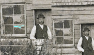
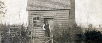
Would I be stretching the imagination too far to suggest that History Geeks photo restoration shows a ferryman at his auxiliary hut? Possibly even in Oamaru. We don’t know who or what the photo was of or even, for sure, if it’s in New Zealand. My guess is that he is a ferryman.
With so much traffic over rivers in the c.1870s the chances of someone having a camera and keeping a photo of such a person are in his favor.
“I absolutely adore everything about this photograph. I don’t know where this image was taken, or who the dapper gentleman is. This is a Carte de visite so could be reasonably early, my best guess is 1870s – 1890s. I found it here in New Zealand but unsure if it was taken here or not. It certainly has a frontier vibe about it.” – History Geek (2019)
“Apart from the reflection in the window, the outstanding bit of information is that interesting back fence.
“Why is there an extension above the picket fence? To train some vegetation for shelter from the wind…from the sea? We would cut away that broom but perhaps this man is thankful for it as shelter.” – AHNZ 2019


If he is a ferryman? I’ll put a dollar on,” Jimmy the needle”. The gentleman in the photo matches Jimmy’s physical description and bares a resemblance to one of his sons who resided in Hebert, Otago. Just a wild guess.
Thank you. Wild guesses are the fuel we run on.
“Jimmy the Needle was given his nickname when he was whaling as all whalers had nicknames – his was based on two major factors – he was tall and thin with disproportionately long legs and secondly he was described as ‘cute, sharp and sly in his dealings'” – Lammerlaw (2011)
Certainly the most likely suspect.