1929: Auckland’s Lost Lake, St. John
July 4, 2019
By AHNZ
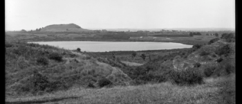
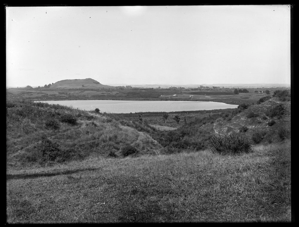 Auckland’s lost lake: Lake Waiatarua. Also known as Lake St. John. This fresh water lake was once considered for use in the metropolitan water supply but somehow or other subverted in favour of sources in the Waitakeres.
Why? Probably because property developers wanted land more than the lake. In 1929 the whole thing was permanently drained outright and erased from history. Now it is housing, the golf course, and a park called Waiatarua Reserve, Remuera.
“Waiatarua came up for contention as a water supply option in the early 1870s – – and didn’t lose out to the Waitakere dams, but to Western Springs. One reason could well have been because Auckland City didn’t have clear title until it was finally vested in them by the Govt in the last century, whereas they bought all of Western Springs from William Motion (and surrounds south of Great North Road from others).”
“Flooding concerns was one of the reasons for Waiatarua’s demise. Once it was more swamp than lake, yes the mosquitos came into it (but folks also complained about the fountain at Albert Park for the same reason). Really, it was just in the way of roads, so once Council had the lake bed, that was that.”
“As was predicted by Lucy Cranwell in the 1940s, money was spent this century in creating the wetland and reserve that had existed naturally before. The way we treat history, really. Either cyclical, or we repeat it.”- Lisa Truttman, Timespanner; July 2018, New Zealand: History & Natural History
 The public relations story went that it wasn’t really a lake just a flood plain that rose and fell seasonally and facilitated the mosquito pest. We’ll get rid of that annoying lake for you; You’re better off!
 In my opinion Auckland has been robbed of a perfectly viable lake that persisted through time and that political skulduggery is at play. Who can be sure? This is the same lake the acclimatisers introduced catfish into back in 1877. The remains now stand as rugged weedy wetlands so are we better off? Perhaps it’s a matter of taste. I’d prefer the lake!
—
* See previous post
2005: State Jihad on Catfishing
Image ref. John Kinder, 1861 showing Mt Wellington behind the lake
Image ref. Henry Winkelmann photo, 1916 showing Mt Wellington behind the lake
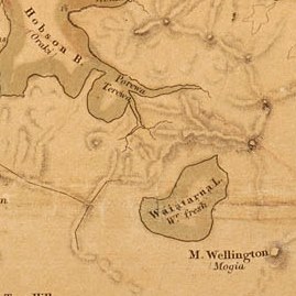
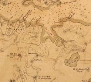
Image ref. Maps from 1842, Capt. Owen Stanley R.N. & Felton Mathew
Sir George Grey Special Collections, all


1929: Auckland’s Lost Lake, St. John
Hi There,
Do you know what happened to the original pipes that drained the lake? Do you have a drainage map resource for where these were?
Thanks for asking. I haven’t sought those details but do see in the Sun (1929) that Mr J Tyler was acting engineeir for the City Council on this project. They emptied out to the Orakei Basin.
I don’t know, but always assumed that the big drains by Koraha Street are them.
That so? I’ll go take a look next time I’m there.
Suggest asking Timespanner as she is an expert on Auckland in detail. You can find a link to her work from here..
http://ahnz.anarkiwi.co.nz/new-zealand-history/
Please include me in the quest. Love to learn more.
The drain went from near what is now Towle Place, straight through the ridge to the Orakei creek.
https://atojs.natlib.govt.nz/cgi-bin/atojs?a=d&d=AJHR1917-I.2.1.4.17&e=——-10–1——2–
I took a walk from Towle Pl at the start of the month and found the start there alright. Sure does cut through the ridge in a northern pipeline marked on the council maps as “1005 Other” and “1005 Concrete.” Under the trampoline in the back yard of 44a Meadowbank Rd takes a NW turn joining with other pipelines to Terewa Creek that leads into Orakei Basin.
Before finding the map I thought the pipeline would take the shorter route into the creek behind Meadowbank School. Inspecting it, there was far less water coming out there than was going in back at Towle Pl. But I wonder why the shorter way wasn’t taken?